Help and Support » Features
New Feature: Recurring Routes
The feature presented here is a premium feature that is only available to premium users. You can take out a Premium subscription via the corresponding upgrade page.
Have you been out on your home course again, but don’t really know how to assess your performance? And how often have you run this route? Ten times or even more? Runalyze has the answer for you with the latest update.
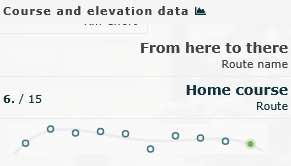
Runalyze now compares all your routes with each other and groups them together if the routes match. In the activity view, in addition to the “Route name” field, there is now also the “Route” field – provided there is at least one other match for the route of this activity. The ranking and number (here: 6th fastest time in a total of 15 activities on this route) as well as the last ten times up to the date of this activity are displayed as a small graphic. Click on the field for a detailed view.
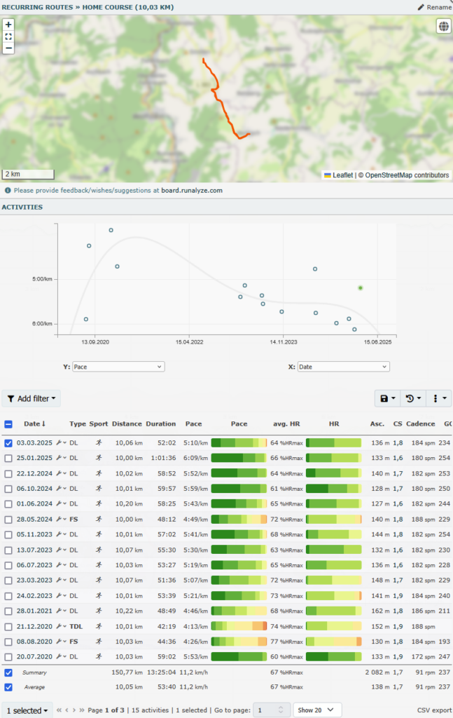
The route itself and all associated activities are displayed in the detailed view. In the route view, the exact routes of the activities are also displayed in green, as long as there are a maximum of 10 activities. The activity list contains a diagram in which the pace is displayed by default. However, the metric can be selected dynamically for both the Y-axis and the X-axis.
The activity list is based on our new activity table, which will be used in many places in the long term. The columns displayed are based on the configured dataset, but can be customized using the three-dot menu. Different views can also be saved and loaded here. The table can also be dynamically filtered (by clicking on “Add filter”) and sorted (by clicking on the column headers).
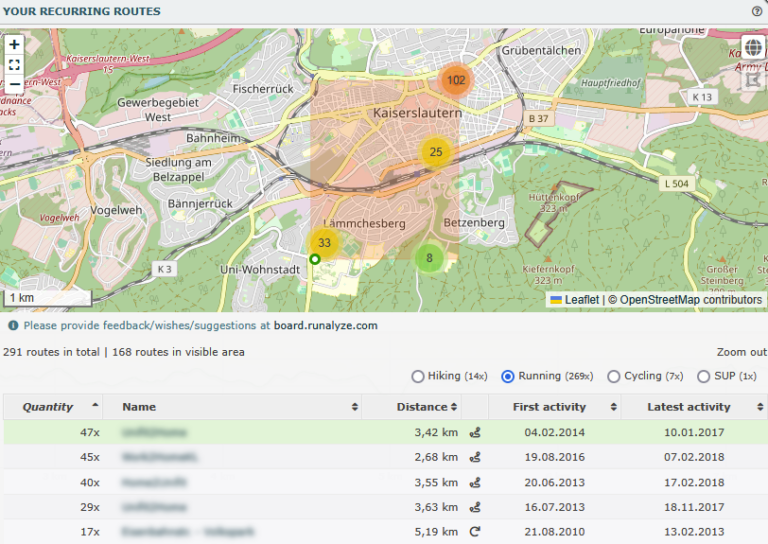 The list of all recurring routes only shows routes for which there are at least two activities. The list can be filtered by sport and clicking on a line automatically zooms to the corresponding map area. Only the routes in the visible area are displayed in the table. Clicking on the name of the course takes you to the detailed view. By default, the place name of the starting point is used. However, all routes can be renamed manually. In addition to the distance and first/last date, an icon is also displayed for each route to indicate whether it is an A to B route or a circular route.
How does the route matching work? First, possible matches are determined for a new activity via the distance, the start/end coordinates and the minimum/maximum coordinates (i.e. south-western/north-easternmost point). A maximum difference of 200m or 4% for the distance is permitted. The routes are then compared with each other (via dynamic time warping) and evaluated. The resulting value must be below a certain limit for a match. The sequence plays a role in the comparison and differences are “penalized” quadratically. It is therefore not a problem to be on the other side of the road from time to time, but it is more of a problem to take a short detour.
The same route was not recognized for my activities, what can I do? In future, we want to offer the option to merge different routes. This will raise the threshold for comparing these routes. Please give us some time to add this.
You have questions, comments or wishes about this or another feature? Let us know! The best place to ask questions about this tool is in our forum.
Do you have an idea or a feature that you really want to see in Runalyze? Submit it on our ideas platform.
Related articles
Didn't find an answer to your question?
Please let us know if you have wishes or have encountered bugs. We give our best to make Runalyze as good as possible for you. - Therefore we would be interested in your suggestions for improvement. In general most questions, problems and ideas are more appropriate to ask in the forum.
